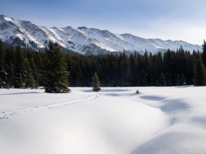
“A stellar day today traversing from east elk pass to west elk pass with great views over the elk lakes valley.” -MaSid
Click on the above photo from MaSid for the full size.
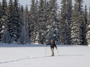
Thanks to Erin P for the following report, and to her dad Jeff G for the following photos:
Elk Pass to what MaSid called East Elk Pass meadow
My dad, Jeff G, and I started off at the Elk Pass lot at around 10am and -15 degrees (no wind, so it didn’t feel very cold). We lucked out and enjoyed fresh and crisp tracks to match the fresh and crisp weather… great job groomers!
Dad’s skins and my green wax were both great on the fresh tracks. At the Blueberry Hill junction, we were debating which great option to follow. Luckily, MaSid was there and suggested visiting his couch at East Elk Pass, which neither dad nor I had ever done (he assured us that it was doable with our skinny skis).
The fresh grooming ended at the top of Elk Pass, and the approx. 1km of Tyrwhitt that we skied to get to the trail to the couch was fine but had a lot of needles and debris.
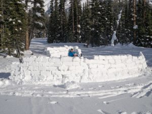
After under 2km of picking our way through beautiful meadow and woods, we arrived at the couch, wind wall, and absolutely gorgeous scenery! We also had a really great lunchtime chat with MaSid. If anyone wants something a bit different and off the beaten track, I highly recommend checking it out!
Temp was -6 when I left and my green wax wasn’t working as well as it had been in the morning…I was grateful for all the downhills on the way back!


Can you connect West and East Elk Pass or is EEP just an out and back?
I’ve skied WEP to both couches there and climbed back up the power line.
I’ve also connected WEP to Blueberry.
Trying to picture this new area I haven’t explored yet.
Anybody got a map of the whole area, couches and routes all labeled?
Traverse is described in MaSid’s Backcountry Trip Report from yesterday.
I used to think it’d be great to dump here a bunch of google-earth mark-up maps, but a certain couch builder convinced me – it’s best not to spoil that “self-discovery” that can really stoke people.
Unfortunately, traversing east to west (or vise versa) linking the two passes directly is back country terrain, involving potential avalanche risk, route finding challenges, and all the other attendant risks, hence why no detailed route description or how to map. Enough info was provided, for people with the appropriate skill set and experience, to figure it out without issue using resources already at hand. The out and back to the border at east elk pass when sticking to the main track, if there is one, is reasonably safe terrain which can be accessed by LT gear, and sometimes cross country gear. It’s up to the user to determine and manage their own safety, including finding the way, when wandering about in the back country. Insert legal indemnification statement here:
They say the East Elk Pass Wind Wall is visible from outer space.
Perhaps. And when does google do the next satellite imagery update in that area?
Couch H2.0 is where it’s at in good weather. A bit cooler than west elk pass normally, unless a pure west wind. East elk better protected from west wind than west elk. East elk exposed more to south wind, hence the large wind wall. Best done when completely clear for the long view to the south. Unfortunately there was cloud down that way today, obscuring the far off peaks.
Hello MaSid or Bob,
I have never been to the couch(s), to reach East Elk Couch I take the trail heading South from Tyrwhitt at the base of the big hill when coming from Elk Pass?
Merci
Jean-Francois, I believe that’s correct. You’ll have to put on the brakes as you’re coming down the hill or you’ll miss it. East Elk Pass from Tyrwhitt directions. It’s only fitting that you’re the one in this photo!
Yes, entry to east elk pass is at the low point on south tyrwhitt approximately half way between elk pass and the tyrwhitt picnic table (the boulton creek drainage). It’s just at the bottom of the steep black diamond portion before you start going back uphill towards the table. Requires descending the hill slowly as bob says so as not to blow by it. It’s a bit of a hard right on light gear so blowing by it not such a bad thing. Not to be confused with the off trail route that heads south from the first flat meadow immediately below elk pass. That route heads up the boundary cut line to the top of Fox-Tyr Ridge (unofficial reference). Go past this first meadow to the next one at the base of the steeper descent. Track is solid and in decent enough shape for light waxable gear currently if a proficient skier. It’s a gentle ascent, maybe a couple hundred feet over a couple km with maybe a handful of herringbone steps here and there to get through little dips. Options to extend travel south past the border for another 2 km through the meadows and into the tobermory creek drainage proper until it narrows and becomes steeper, for a total of 4km one way off trail. Less travel on the extension south of the border and somewhat blown in, but track still visible. Return the way you came. Highly recommended on a bluebird low wind day. Bring a camera, a foamy to sit on and a warm jacket to enjoy it for a while. It gets sun well into the the late afternoon. No avalanche hazard staying on the main track to the border.
Thanks MaSid and Bob, I remember seeing the trail when on Tyrwhitt and wondering where it would lead.