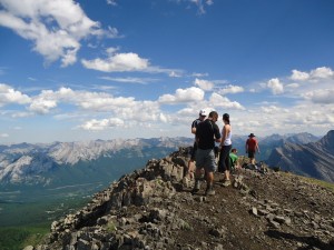
– HikerBob on the summit of Mt Allan –
You can’t use enough superlatives to describe the views on this hike: Spectacular, incredible, astounding, stunning, breathtaking.
The Centennial Ridge/Mt. Allan hike, at 1400 metres(from the north approach)is the most net elevation I’ve ever done. The hike is gruelling enough on its own, but I chose the hottest day of the year to do it, with a temperature of +30 degrees in the mountains. I wish I had chosen to do this hike when I was young and fit, but at my age, I guess it gives a greater sense of accomplishment. I was completely worn out when I finally reached Ribbon Creek, 9 hours after starting out. All worth it, though.
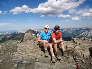
Amanda and Tyler had reached the pinnacle of Mt Allan about 10 minutes before I showed up. They took the south approach from Ribbon creek.
I was lucky to be able to do a one-way trip(total distance 19K), starting from the north trailhead at Dead Man’s Flats and hiking through to Ribbon Creek. Most of the research I did beforehand suggested the short, steep south approach was the most scenic, but now that I’ve seen both sides, I would beg to differ. They are both equally magnificent.
Beginning at the north end also allowed me to have some cover from the hot sun for the first two hours, as it is forested for most of the first 8K, but occasionally opening up to provide glimpses of the Bow valley, Pigeon mountain, the Three sisters, Wind ridge, and Mt. Lougheed.
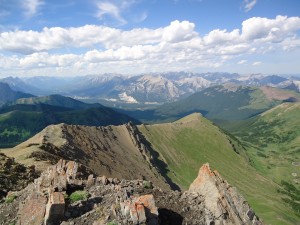
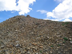
Approaching from the north, I walked along this entire ridge. A large portion of the ridge is not visible as it is at a lower elevation. The entire ridgewalk from the north approach is about 3K with an elevation gain of 550 metres.
Now that I’ve completed the hike, I can identify with this quote from Gillean Daffern’s Kananaskis Country Trail Guide: “Not many people do the whole traverse, because it requires two vehicles and a spare pair of feet, knees, hips, etc.” In retrospect, I think it would be easier and more pleasant to descend the north side as it is much more gradual than the steep south side.
The north trailhead is at Dead Man’s Flats near the Banff Gate Mountain Resort. It serves as the beginning point for a number of other hikes including Skogan pass, Pigeon mountain, and Wind ridge.
After climbing for about an hour, there’s an opening in the trees which gives a beautiful view of the Three sisters, Wind ridge and the Bow valley. I could see the Wind ridge trail very distinctly.
If you don’t have the stamina to go all the way to the peak, this could be a very satisfying hike to the 8.5K mark. As you emerge from the trees at 7.5K and 750 metres elevation, you find yourself in a gorgeous meadow(I believe it’s known as the “hanging valley”) between Mt Collembolla and Mt Allan. It’s secluded and peaceful, with lots of flowers, and a good view of the ridge which you’ll be hiking on all the way to the peak.
From the meadow, if you continue on for about 1K and 100 metres elevation, you’ll reach the main ridge and have wondrous views. Eventually you’ll reach a rock band where some agility is required, as you will be required to use hands, feet and knees to pull yourself up about five metres. If you have tender city-boy hands like mine, a pair of leather gloves would help . This might be a good turn-around point for anyone wishing to do a less strenuous hike.
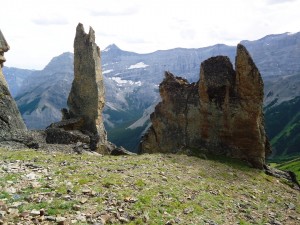
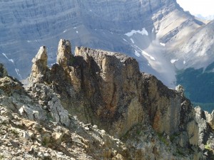
Hiking the final 3k to the pinnacle is along the ridge, and passes over a number of lesser peaks and some outstanding and unusual rock formations. To your left is the valley between Collembola and Allan, where you’ll see four tarns on the valley floor.
I was happy to see Amanda and Tyler lazing about on the summit when I finally reached it. My GPS indicated that I had climbed a net elevation of 1392 metres.(The accumulated elevation for the entire hike was a whopping 1984 metres).
It’s good to have a Gem-trek map along to pick out the various peaks and features. From the top, you can look waaay down and see two of the emerald-green Memorial Lakes. Many years ago on a Calgary Ski Club hike, I remember eating lunch at Memorial lakes and watching with binoculars the hikers waaaay up on the Centennial ridge trail.
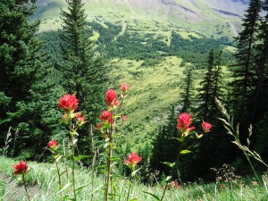
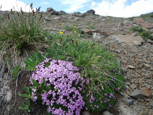
I saw a greater variety of flowers on this hike than I did at Sunshine Meadows last week. It seems that you’ll see a new species of flower for every elevation zone you pass through.
If you’re wondering whether to make the complete traverse, I would highly recommend it. You’ll miss out on a lot if you choose to do only an “up-and-back” on one side. While researching trip reports for this hike, I read on the Calgary Outdoor Club’s website this misleading statement: “I’ve decided not to make this hike a one-way traverse of the entire trail as the north-side trail soon plunges into forest.” That was obviously written by someone who didn’t make the spectacular 3K ridgewalk which ensues as you descend the summit onto the north side, nor did they walk through the gorgeous flower-filled hanging valley between the two mountains.
This has to be one of the best hikes ever.



Just did this hike for the second time Nakiska to Deadman flats, the first being the opposite direction several years ago, be aware this direction is very badly signed on the final decent back to Deadman flats we had a nightmare navigating back as we missed the turn off and ended in a washed out part of the creek that has not been repaired since the flood, apart from that its a wonderful hike.
I had a similar nightmare on this hike but going from Deadman’s back in 2000 with a beautiful Rottweiler named Corona. Got lost in the many logging roads/cutblocks and went up and down so many wrong turns, we finally ended up at Ribbon Creek at 9:30 pm. I should have a had a GPS then and still need/want one now and the techie brain to go with it. Bet you and Jip2 would have appreciated a nice cold snowball greeting yesterday. I did King Creek Ridge (620 M in 3 kms.) and slid on my butt a few times. The song “this could be the last time” sure kept running through my head.
Haha our paths cross again Helen, Jip was the only one pleased to see the trail abruptly end at the washed out creek , she raced into the water and languished there in delight as we sworn in the heat being eaten alive by mosquitoes.
Hi Bob! Great post – thanks! I’m writing you from BC. I’m wondering if one could camp or bivy somewhere along this route? Thanks! Jonathan
Unfortunately no.
In the parks (vs other designations or areas i.e.wildland etc) you may only camp in designated sites and have purchased a permit.
Most of this hike is in Bow Valley Provincial Park and random camping isn’t allowed. Check this link for more information http://www.albertaparks.ca/kananaskis-country/information-facilities/camping/backcountry-camping/random-backcountry-camping/
Darn! Are there 2 day hikes in the area where camping is allowed?
A bit farther south maybe look at Northover ridge? Or The forks campground up to Turbine? Wouldn’t recommend the South and North pass circle though, unless it’s been fixed up or bypass up over the pass just past 3 Isle lake. The trail wasn’t very well maintained as you head towards the North Pass as it’s part of BC for this section.. Anyway my 2 ¢, maybe others will way in.
I was curious about the map found on the link that Bob gave.
It appears to the untrained eye that random camping is allowed along part of the north approach of the trail. In addition, bivouac camping seems to be allowed in a small area higher up the north slopes. I don’t have an accompanying trail map, so I may be reading this all wrong.
Now that I take a second look, it is confusing. Where it indicates “Bow Valley Provincial Park” on the lower left, I’ve always known that area as “Bow Valley Wildland Provincial Park” which would mean random camping allowed. I’m away from home and don’t have access to my Gem-Trek maps which would be more precise. Perhaps Jonathan could phone the number provided on the link and get a clearer answer. I found this other map which shows what I believe are the boundaries of BV Wildland PP, which would indicate random camping is allowed for the entire north approach. The south approach is in “Evan-Thomas Recreation Area” where random camping would not be allowed. Map
It would appear the Alberta Parks website has the map labelled incorrectly.
Hi all!
I appreciate the help with my question! Thanks! I think that we will hike the Iceline Trail now as it seems more camping friendly.
Jonathan
Nice choice. Great camping at Takakkaw Falls as perhaps a base camp and then Little Yoho if you wish to extend your stay in the back country or make a loop.
Watch out for the intelligent, hungry ravens at Takakkaw Falls! Don’t leave any food out, even for a minute -)
Hi Bob…my friend Deb and I saw you this past winter at Moraine Lake…x-country skiing. You took our picture of us two girls (Deb & Deb) 🙂 My hubby and I are going to hike Centennial Pass up to Mt. Allan and back, starting at Dead Mans Flats….and I am trying to get my hands on as much info about it as I can. We are used to doing 26-29km in a day hike/climb…and so are really looking forward to it…thanks for the nice synopsis and pictures…good on you! Looked like you had a wonderful time!
Warm regards
Deb & Vern
Hi Deb, yes, I remember you from Moraine Lake road(http://skierbob.ca/2011/11/the-best-xc-skiing-on-earth/)
Take lots of water if it’s a warm day. I had 2 litres and it wasn’t enough. -Bob