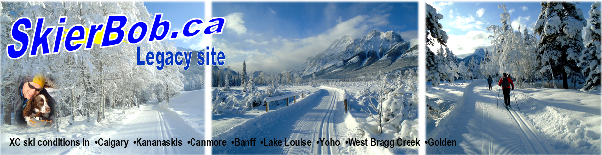

Lionel ski trail in 1982. Photo by Henry L
Mar 13, 2021: Skiing from the winter gate to the back door on Hwy #40 would be about a 9K trail. Thanks to Alf Skrastins for this great idea:
The Nordiq Alberta ski pass program has been a huge success. It has provided us with exceptional ski grooming plus the bonus of extra funds that could enhance skiing opportunities for next year.
Lionel ski trail in 1982. Photo by Henry L
The value of those surplus funds are not enough to purchase much equipment or to build much new trail.
So, my suggestion is to make better use of what we already have. Decades ago, Highway #40 was groomed for skiing from the winter gate to the Pocaterra “Back Door”… it was known as the Lionel trail.
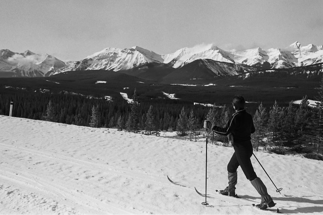
Hwy #40 in PLPP. Formerly known as Lionel ski trail.
Given the popularity of the Moraine Lake Road, grooming Highway #40 should be a no-brainer.
Ideally, the winter gate would be moved south by a few hundred metres to provide a paved parking lot. Add some portable toilets and a portable trailhead kiosk, and you’ve got a functional trailhead.
I would suggest that the highway could be groomed for multiple uses. Classic track setting would create an ideal “easy” trail. And it would create an obvious loop with Pocaterra trail.
A wide skate lane would provide an opportunity for skate skiers. A separate groomed lane could be created for fat-bikes, hikers, snowshoers, skijoerers, winter hikers, etc.
That is a small infrastructure cost, no additional grooming equipment… but more grooming staff time… and it would produce a tremendous addition to the PLPP trail network.


The Bob Trail?
I vote for keeping PLPP a skate-free and dog-free zone.
Can I ask why you don’t feel skate skiing should be allowed?
Sounds like a great idea!
That’s a terrific idea. I would use it.
I would assume that they would need more grooming equipment to take on more trails. They haven’t been able to keep up the trails they currently have after snow falls. When I last skied out there the trails we picked were is very rough shape, despite the groomers working long hours.
Hi Jon, no extra equipment is required. The snowcat is usually doing only one shift per day, so another person to operate the snowcat would be all that’s necessary. An extra shift every day would also allow more grooming on the regular trails.
I should mention that although there is 24 hours in a day there really is only about 10 to 12 hours in a day for a grooming shift. Our trails are just too busy to try and run a cat during the day time. Our equipment costs in the neighbourhood of 300,000+ . They really aren’t designed to run non stop everyday. If they are over used the cost of maintenance goes through the roof. In the glory days in PLPP there were four groomers and two snowcats As they also groomed Mount Shark, all of PLPP and the Chester Sawmill system.
I am all for new trails but it has to be understood that equipment and manpower is not an infinite resource. As much as most of us groomers love what we do we also enjoy spending time with our families and getting the chance to ski the trails we look after.
Great input to the conversation Jeff! Thanks for providing the other side of the equation and the grooming history of K-Country.
My memory tells me more grooming occurred in the “good old days”, but memories aren’t always reliable.
Gotta hand it to Alf. He’s always got his thinking cap on.
These are the views we would get from Lionel trail opened to skiing.
https://www.dropbox.com/s/3huirfo3rwqw375/Lionel_trail_ski_circa_1982_1920px-1.jpg?dl=0
https://www.dropbox.com/s/oyi7wypyhiglqfd/Lionel_trail_ski_circa_1982_1920px-2.jpg?dl=0
I love the idea of resurrection of “Lionel” but I can’t see it possibly going South of the “Back Door” due to Avalanche risks. Parking lot at the winter gate would be a nice addition and definitely need to bring back the trail connecting Pocaterra to “Lionel” which would allow for a loop.
Does anyone know why Lionel was decommissioned in the first place? What about the other decommissioned trails such as Sounding Lake, Rockwall, Canyon and Lakeside? I’m only 30 and never skied on any of those before decommissioning but my parents did and they have an old map from 1983.
Ever hear of Ralph Klein? Budget cutbacks? Eliminating the deficit?
Lots of trails and facilities were lost during that era…
I could go on, but I’d start sounding MAAD
Alfonse!
The old Sawmill xc trails along Smith-Dorrian Road, why can’t those be resurrected?
Sara Speed Jeans
They already are, but pretty much all snowshoe now I believe.
I was skipping through some old self made videos of doing the trails there, no tracksetting, narrow and fast!
Better check with Lionel.
I agree that the Hwy 40 groomed trail with an enlarged parking area on the existing pavement would make an excellent addition to the PLPP ski trail system. Another idea worth looking into would be to reintroduce the old alignment of the Pocaterra Trail from Pocaterra Hut to the Lynx junction. The trails were already there so a rebuild of the old bridges would allow for yet another beginner route (that we used to have) rather than the at best intermediate route when the trails were raised out of the valley. Yes the area flooded but how often? It would be interesting to find out an estimated cost for a project such as this.
The bottom line is that the monies left over from grooming should ONLY go back into the various areas where Kenney and Nixon made us pay for parking.
I like the idea of resurrecting Lionel. Earlier this year I skied from Boulton up Packers, out the Back Door, and on towards Highwood Pass. The section south of Back Door is very scenic and would make for an excellent xc trail as well. Being less protected by trees, the road does get more wind and drifting snow, though.
Great idea Alf!
Carl- looking at the satellite image, there appears to be nothing of concern regarding avalanche hazard up to at least the “back door”.
Cindy- I think the wildlife aspect of the closure applies more to the Highwood valley south of the pass, where open slopes and much less of a snowpack provide important overwintering terrain.
Thank you for the clarification. If impacts to wildlife aren’t the issue, the only comment I would make then is that anyone can ski there now and skiers can set their own tracks. Even beginners can do this. However, I think the opportunity for a skate lane is an interesting one as I think it would be good for increased facilities for skate skiers (and this road would be perfect). I also strongly feel our government should be doing the appropriate studies and research on connecting its citizens with nature and recreation, prioritizing this aspect of society (as the benefits are real) and allocating appropriate resources and funding to this (with proper public and first nations consultation). I don’t mind the thoughtful partnering and /or implementation of a user pay facility (such as the CNC) but I feel there should also be publicly paid trails. I believe Kananaskis was set aside to primarily benefit Albertans (and to a small part various ecosystems) and so changing the funding model for this park shouldn’t be a knee jerk action.
Finally, with climate change we’re going to need ski trails at higher elevations. Perhaps it’s worth considering grooming the Sawmill trails again as ski trails? I seem to recall years ago a wonderful set of ski trails here. I believe these are at higher elevation as well? and might last longer than most.
Finally, despite my not supporting a user pay system for grooming, I really want to thank the amazing work of our groomers and trail maintenance crews. Every single time I went out to ski the conditions were beautiful…even if some of the trails weren’t freshly groomed for that day it offered a great variety of ski experience which I love. And thank you Bob for putting up with my comments and building a strong cross country ski community not only through this blog but also through you on-trail relationship building.
I too would love to see the Chester-Sawmill trails resurrected! They are at a much higher elevation, with a much longer possible ski season, and they were fantastic ski trails which I really loved and was very sorry to lose.
It sounds like it would be a much bigger project, though, so rather a big challenge to get off the ground. I do wonder why they were given to snowshoers when the snow up there is so wonderful for skiing?
Because there was no money for the very expensive job of grooming ski trails. You can still ski those trails… just bring touring gear.
I think before a decision is made there should be an assessment on how it may impact the wildlife which is the primary reason for the road closure I believe.
The road closure, Highwood House to Kananaskis Lakes Road, protects primarily the sheep and elk herds wintering in the Highwood River valley south of Highwood Pass.
The Gem Trek map, Kananskis Lakes, shows a Wintour snowshoe trail (~5km) on Hwy 40 to Opal Falls. Another ~5 km beyond is the “back door” Kananaskis Lookout access road. Likely skiing on the more exposed road allowance wasn’t that popular.
His Bob,’
I found this 1986 map from an old post you posted a few years ago and I guess the same map Carl is referring to.
http://skierbob.ca/wp-content/uploads/2014/03/North-trails.jpg
Cheers
JF
Wow, that brings back memories! Love seeing old maps.
I love this idea, but when I posted an enthusiastic note about doing this on Dec 19 2020 someone replied that they thought that Lionel had been decommissioned because it crosses an avalanche path.
That rang a bell for me, but I can’t think where that might be between the gate and the back door.
According to my 1980’s map, Lionel did not go all the way to the gate, but branched off from the old Pocaterra near the Rolly Road and Come Along junctions. It was marked as .8 km intermediate and 7.2 km easy.
An excellent idea. A loop connection would be good, allowing return from pocaterra to Hwy 40 parking. Not sure how feasible that would be given height gain/terrain. Same with extended grooming further south, allowing easier access to other terrain, but not essential (kinda like extending beyond MLR grooming to moraine lake). But also quite open and exposed to the elements. Worth a “pilot project” test regardless. Lots of cars were parked there the other day using the road.